


RD-De La Frette à Bévenais

raymondfn
User
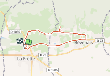

Length
7.3 km

Max alt
517 m

Uphill gradient
142 m
Km-Effort
9.2 km

Min alt
427 m

Downhill gradient
135 m
Boucle
Yes
Creation date :
2023-12-04 16:54:30.507
Updated on :
2023-12-04 16:59:44.867
2h05
Difficulty : Medium

FREE GPS app for hiking
 SityTrail
IGN / Geographical institutes
SityTrail Plus
The world is yours!
About
Trail Walking of 7.3 km to be discovered at Auvergne-Rhône-Alpes, Isère, La Frette. This trail is proposed by raymondfn.
Positioning
Country:
France
Region :
Auvergne-Rhône-Alpes
Department/Province :
Isère
Municipality :
La Frette
Location:
Unknown
Start:(Dec)
Start:(UTM)
684556 ; 5029300 (31T) N.
Comments
